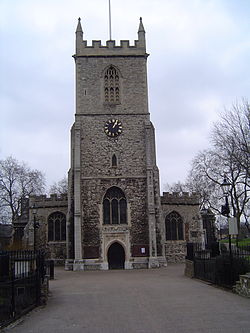
Of the many joys of living in Tower Hamlets, one of the greatest is discovering and appreciating its historic gems. Take the ancient Church of St Dunstan and All Saints in Stepney, for example.
Anyone who hasn’t taken a look inside or strolled in its grounds is missing a treat. Its guidebook is fascinating, detailing how Dunstan, who was a Bishop of London and Archbishop of Canterbury and later canonised, dedicated the site as a church in about 952. It adds:
The church building took its present shape a little before Columbus sailed for the Americas. It is the mother church of the East End and with the ancient Port of London nearby became known as the Church of the High Seas. For this reason, the red ensign is still flown from the tower, which also houses the famous ten bells of Stepney, mentioned in the nursery rhyme, Oranges and Lemons – ‘when will that be, say the bells of Stepney?‘
Today, after somehow surviving the Blitz – the large stained glass window on the east wall shows Christ on the cross above a bomb-ravaged East End – not only is it famous among family researchers across the world, but it is also a lively parish church which engages with all walks of life in its community (next event, the Christmas Fair at Stepney City Farm on December 15, by way of free advertising!)
In short, the East End and its elected councillors should be proud of St Dunstan’s and be doing everything possible to preserve its place in our borough. After all, history is vital to our shared identity.
Which is why it’s a little surprising that amid all the fuss being made about the proposed dropping of two relatively artificial ward names (‘Lansbury’ from the East India and Lansbury ward and ‘Banglatown’ from Spitalfields and Banglatown), hardly a word has been said about the potential loss of ‘St Dunstan’s’ in the new Stepney wards.
If the recommendations from the Local Government Boundary Commission for England are accepted after the current consultation period ends on January 7, possibly the most famous parish name in the country will be removed from the electoral map.
Instead, the current St Dunstan’s and Stepney Green ward will, with the additions of various parts of Mile End and Globe Town and Whitechapel, become Stepney West and Stepney East.
This is Labour’s fault and I’m hoping it was an unintended consequence of trying to resolve a fairly complicated problem about changing population numbers. Whereas Mayor Lutfur Rahman, very much to his credit, and the Tories both recommended keeping St Dunstan’s, Labour wanted to create new wards to accommodate the vast Ocean Estate.
Here’s what the Labour Group wrote in its submission to the Boundary Commission:
Stepney West
77. A new Stepney West ward takes in part of the existing Whitechapel ward east of Sidney Street and an area from south of the A13, currently in Shadwell ward. Its southern boundary is Cable Street. The eastern boundary follows Butcher Row to the Commercial Road and then turns up Bromley Street and a short section of Stepney High Street to Ben Johnson Road. The northern boundary to the ward follows Stepney Green and then goes along Redman’s Road and north to Mile End Road.
78. This area is recognised as Stepney by local residents. It includes Stepney Green Park and the Sir John Cass’s Foundation and Red Coat School. It incorporates major housing estates including the Sidney estate and Clichy estate.
79. With two councillors, the ward would have three per cent more than the average electors per councillor in 2018.
Stepney East
80. A new Stepney East ward’s eastern edge is clearly defined by the strong border provided by the Regents Canal and Mile End Park. The northern boundary is the Mile End Road. The southern boundary follows that described above for the northern boundary for Stepney West ward. It then goes south down Bromley Street as far as southern edge of the park around St Dunstan and All Saints church and down White Horse Road as far as Salmon Lane. The boundary then follows Salmon Lane to the Regents Canal.
81. The new ward incorporates the Ocean estate in its entirety, an estate which is currently divided between Mile End and Globe Town ward – polling district MGT4 – and St Dunstan’s and Stepney Green ward. The estate has a very strong identity which was reflected in it being selected as a New Deal for Communities area under the last government. The estate has a strong residents association. It has a doctor’s surgery which is being refurbished and a children’s centre. The estate as a whole represents a catchment area for both of these facilities. Stepney Green secondary school is used by children from the estate and the shopping parades on White Horse Road and Ben Johnson Road, currently in different wards, are also used by residents from across the estate. The ward also includes the Limehouse Fields estate which is south of Ben Johnson Road.
82. With two councillors, the ward would have one per cent less than the average electors per councillor in 2018.
Here’s Lutfur’s submission:
6.8 St Dunstan’s and Stepney Green
The area covered by the current St Dunstan’s and Stepney Green ward constitutes a real community, bounded by Mile End Road to the north, Commercial Road to the south, and the Regents Canal to the east. Notable local landmarks that form part of the contemporary community identity include the Stepney Green conservation area, St Dunstan’s Church (founded in 923) and the Stepney City Farm.
However, the southernmost part of the current Mile End & Globe Town ward is also part of the St Dunstan’s/Stepney area. Just as nowhere north of Mile End Road or south of Commercial Road could be considered to be Stepney, this area in between these two unarguable boundaries is universally held to be part of Stepney. Indeed, prior to the last review, polling district MGT4 fell within the St Dunstan’s ward, and rightly so: residents in the area consider themselves to live in Stepney or St Dunstan’s, not Mile End. This polling district is dominated by the Ocean Estate, part of Stepney.
The two communities are divided by a major road, the A11, the integrity of which is preserved as a boundary between all other wards which fall on either side of this road. It seems nonsensical for Mile End & Globe Town ward alone to stretch over the A11 to include this part of Stepney.
Accordingly, I propose to include all of polling district MGT4 in the new St Dunstan’s and Stepney Green ward. When this polling district included, the numbers are ideal for a three-member ward.
And here is what the Boundary Commission concluded:
Stepney
77 The Labour Group proposed a two-member Stepney West ward and a two- member Stepney East ward. These wards were proposed to have an east–west orientation and were split along Bromley Street and Redman’s Road, uniting the properties along Stepney Green in the Stepney East ward. The Group argued that these arrangements maintained estates within the same ward and incorporated an area ‘recognised as Stepney by the local residents’. The Labour Group proposed that the southern boundary of its Stepney West ward should extend south of Commercial Road to Cable Street. However, the southern boundary of the Labour Group’s proposed Stepney East ward did not extend as far south as Commercial Road. Instead, the boundary proposed by the Group would follow the minor road of Salmon Lane.
1478 The Mayor and Conservative Group both proposed north–south arrangements which used Commercial Road as a southern boundary and split the Stepney area vertically. The Mayor proposed a boundary along Jubilee Street. The Conservative Group proposed that the boundary should use West Arbour Street. The Conservative Group argued that, although its boundary did ‘not follow any major road or dominant physical feature, this is the case at the moment also, and the proposed boundary does not divide any estates’. The Conservative Group argued that the current ward boundary along Jubilee Street – which was proposed by the Mayor – divided the Clichy estate. The Mayor did not provide any community evidence in support of his proposed boundary along Jubilee Street.
79 Having walked the area, we are of the view that the diverse estates and housing in Stepney are linked by Stepney Way, which runs east–west in the area. We are of the view that neither the Mayor nor the Conservative Group provided for strong boundaries in their submissions. We are further of the view that the Mayor’s proposal split a cohesive estate along Jubilee Street.
80 We therefore consider that the arrangement proposed by the Labour Group provides for strong east and west boundaries and keeps communities together within the Stepney area. However, we were concerned that the Group’s proposed southern boundary of Stepney West crossed the busy Commercial Road. To provide for both clear boundaries and reflect local communities, we therefore propose that the southern boundary for the Stepney West ward should run along Commercial Road. As a result of the recommendations for Limehouse (paragraph 57), we also recommend that the southern boundary for Stepney East should be Commercial Road.
81 As a result of these modifications, an electoral imbalance of -22% would result in the Stepney West ward. We therefore propose two further modifications to ensure improved levels of electoral equality in the ward.
82 Firstly, we propose that the north-east boundary of the Stepney West ward be extended to run along the backs of the properties on the east side of Stepney Green. This ensures that the houses along Stepney Green are not divided between wards. To the east, we propose to extend the ward’s eastern boundary to Belgrave Street, a road with housing consistent with much of the housing in Stepney West. For the remainder of Stepney West and Stepney East, we have decided to adopt the Labour Group submission without modification. As a result of our recommendation, the wards of Stepney East and Stepney West would have 5% fewer and 7% fewer electors than the borough average by 2018, respectively.
I’m hoping that the likes of Mayor Lutfur and the three current ward councillors, Independent Oli Rahman, and Labour’s Abdal Ullah and Judith Gardner (who spoke passionately about the need to preserve the borough’s heritage during a debate on the sale of Henry Moore’s Old Flo at last Wednesday’s council meeting), will now voice their concerns about this apparent oversight.
Of course, the work of St Dunstan’s and All Saints’ Church will continue regardless, but if we’re quite rightly (in my view) campaigning to preserve Banglatown on the political map for heritage reasons, then surely we need to be consistent with a name that has a much longer history.
I’m not sure what the solution is, but what about the wards being called Stepney West, and Stepney East & St Dunstan’s?
Perhaps we need to start a petition for this. In the meantime, people can also protest to the Boundary Commission via this address: reviews@lgbce.org.uk .
UPDATE – Monday, 12pm.
Oliur Rahman, an Independent ward councillor for the area and a member of Mayor Lutfur’s cabinet, is backing the retention of the St Dunstan’s name. He told me on Twitter earlier that he would support a Stepney East & St Dunstan’s name.
I’ve posed the same question to the mayor and will be doing likewise with Labour councillors.
UPDATE – Monday, 9pm
Labour’s Abdal Ullah, another ward councillor for the area, has also been in touch to say he supports the retention of St Dunstan’s. He said: “As chair of the Labour Faith Network, I strongly support keeping the church name on the ward.”
Share this: Facebook & Twitter
Read Full Post »